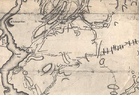
 An early map of the area was prepared in 1778 - 1780 by
Robert Erskine, Geographer to the Army. (See detail at left.)
An early map of the area was prepared in 1778 - 1780 by
Robert Erskine, Geographer to the Army. (See detail at left.)Lake Mohegan or Mohegan Lake...
A Hamlet Rich in History, No Matter How You Say It!
An Illustrated History of
Mohegan Lake
Part 1: Origins to the American Revolution
By David O. Wright
Aboriginal Population -- The First Mohegans
It seems certain that Lake Mohegan was an important site for thousands of years before history records human presence. The lake undoubtedly has always provided a source of water and food, and its watershed plentiful game. However, several archeological surveys have yielded little evidence.
In 1974, Dr. Lon Alterman, an anthropologist then residing in Crompond, conducted surveys and discovered what he believed were Indian fire pits at a depth of about 18 inches below the surface near Mohegan Colony beach and along the Westside of the lake. Residents also reported to him their discoveries of ancient artifacts, mostly arrowheads, during the early development of the lake community in the 1920s.
Some residents on the East side of the lake have reported finding skeletons while digging foundations. This would be consistent with Indian burial practices. They believed the Great Spirit resided at a place called Cantantowit, to the southeast, and buried their dead facing that direction. Thus, we would expect to find graves on the East side of the lake, where the land begins to slope upward.
Alfred Crew Associates conducted a more comprehensive survey in connection with a proposed sewer project in1983. That study concluded that there were several areas around the lake where the possibility of locating archeological traces was slight. Their mapping is set forth here.
Was Mohegan Lake home of the Mohigan Indians? Undoubtedly. At the time of discovery of the Westchester area, the entire region of Eastern New York was home to the Mohicans (also called Mahicans or Mohegans). They were not a part of the Iroquois nations, and in fact were at war with the Mohawks (to the West) for some 75 years during early Dutch exploration.
The names of the Mohican sub-tribes will sound familiar, as many of the tribes' names have been preserved to this day. The Westchester Mohicans were related to the Tribe of Wappinoes (Wappingers) to the North. In particular, the Kitchawangs had settlements at Croton (then called Kitchawonck), where a substantial fort existed at Senasqua Point, and at Peekskill (then called Sackhoes). This sub-tribe ranged through the areas now comprising Cortlandt, Yorktown, Somers, North Salem and Lewisboro.
The earliest historical reference to local natives occurred when Henry Hudson anchored the Half Moon at Peekskill on October 1, 1609. Fascinated with each other, the Dutch and the natives seemed to seek contact. However, a melee erupted after an Indian stole two shirts, two cartridge belts and a pillow, resulting in the death of two Indians.
1600's -- The Dutch Push Northward
Under the Dutch patroon system, members of the Dutch East India Company were permitted to purchase strips of land along navigable waterways, 16 miles long, and going inland as far as possible. The Northern Westchester patroon was Stephanus VanCortlandt, who in 1683 purchased a manor including present-day Cortlandt, Somers and Yorktown.
During the 1600's, from 1626 to 1700, the Dutch effectively wiped out the native population of Westchester County. By 1700, only a few hundred Indians remained, mostly Mohicans. Trading liquor and small goods for large tracts of land, the Dutch pressured the Indians into war in 1643, which resulted in mass slaying of the native population.
By 1712, the Cortlandt Manor contained a population of 91. A map of Cortlandt Manor from 1734, copied in 1877 by hand, shows Lake Mohegan as "Crooked Pond" and MacGregor Pond as "Magrigarlo's Pond"
Revolutionary War
During the Revolution, the colonists enlisted the aid of the remaining Mohicans in fighting the British. Mohicans fought with the colonists at the battles of White Plains, Barren Hill and Cortlandt's Ridge (Yonkers) in Westchester County. By 1780, there were only 20 Mohicans left in the service. They were discharged and given six acres of land in Western New York. By 1880, they were moved to Wisconsin with the Stockbridge Indians. The last few Indian families in the area lived at Indian Hill just West of the Jefferson Valley Mall.
An early map of the area was prepared in 1778 - 1780 by
Robert Erskine, Geographer to the Army. (See detail at left.)
A major tavern was located in Mohegan Lake, on what is now Rte 6, next to St. Mary's church. Monk's Tavern began operations sometime around 1750 as the only stopping-off point between Peekskill and Danbury for nearly a century. Nothing remains of the tavern, located at St. Mary's parking lot.
Although Yorktown and Cortlandt were not the site of any major battles, they figured prominently in affairs of the time. Fort Lafayette was located at Verplank, and Washington visited there in November 1776, after the battle of White Plains. (Cushman 1933:45). Washington established Continental Village as a military depot in the defense of the Highlands area of Northern Westchester and Putnam Counties. Maps of the era show Mohegan and Crompond.
 The French appear to have had a particular presence, not only
at Fort Lafayette, which fell in November 1776. Some 5,000 French troops were
garrisoned at Verplank in September 1781and relocated to Crompond, near Hunt's
Tavern under the command of Jean Baptiste Donation, Comte de Rochambeau.
Lauzan's Legion was stationed to the South, at "French Hill", which
still bears that name. After their victory at Yorktown, Virginia over
Cornwallis, the French returned to Crompond (probably near Hunt’s Tavern) in
September - October 1782. (Yorktown, New York was created and given its name in
1788.)
The French appear to have had a particular presence, not only
at Fort Lafayette, which fell in November 1776. Some 5,000 French troops were
garrisoned at Verplank in September 1781and relocated to Crompond, near Hunt's
Tavern under the command of Jean Baptiste Donation, Comte de Rochambeau.
Lauzan's Legion was stationed to the South, at "French Hill", which
still bears that name. After their victory at Yorktown, Virginia over
Cornwallis, the French returned to Crompond (probably near Hunt’s Tavern) in
September - October 1782. (Yorktown, New York was created and given its name in
1788.)
Another notable historical event was the apprehension of the British spy, Major John Andre, in the area. General John Paulding and others apprehended Major Andre in the Tarrytown area, and were granted land in the area. Paulding discovered papers in Andre's stocking, which outlined plans to take West Point. Today, Paulding Lane in present-day Crompond bears his name. (Horton 1898:98; Horton 1912:98). Crompond was apparently a name with a Dutch origin -- "Krum-poel" meaning crooked lake, the original name for Lake Mohegan. (Bolton 1848;379).
Continuation in a series of predictions about the 20th Century from The Ladies Home Journal of December 1900 (click HERE for the complete list of predictions):
Prediction #4: “There Will Be No Street Cars in Our Large Cities. All hurry traffic will be below or high above ground when brought within city limits. In most cities it will be confined to broad subways or tunnels, well lighted and well ventilated, or to high trestles with “moving-sidewalk” stairways leading to the top. These underground or overhead streets will teem with capacious automobile passenger coaches and freight with cushioned wheels. Subways or trestles will be reserved for express trains. Cities, therefore, will be free from all noises.”
Prediction #5: “Trains will run two miles a minute, normally; express trains one hundred and fifty miles an hour. To go from New York to San Francisco will take a day and a night by fast express. There will be cigar-shaped electric locomotives hauling long trains of cars. Cars will, like houses, be artificially cooled. Along the railroads there will be no smoke, no cinders, because coal will neither be carried nor burned. There will be no stops for water. Passengers will travel through hot or dusty country regions with windows down.”
Predictions 1 through 3 can be found at the end of the December 1999 feature.
The Yorktown Historical Society updates the home page with seasonally appropriate articles and information. Click here to read our past issues.